Fresno County is a participant in the National Flood Insurance Program (NFIP), with a current Community Rating System (CRS) score of seven. This rating provides Fresno County residents residing within and near Special Flood Hazard Areas (SFHA) a discount on their annual flood insurance premiums.
The following GIS links show the locations of the SFHA, which are based off the most current FEMA Flood Insurance Rate Maps (FIRM).
Fresno County GIS
FEMA GIS
El Niño
Fresno County has suffered years of drought and severe wildfires. Heavy rains typically associated with El Niño increase your chance of flooding. For more information on El Niño , visit the following links:
National Flood Insurance Program
NOAA El Nino Theme Page
Flood Management Services
Map Services
The Federal Emergency Management Agency's (FEMA) Flood Insurance, Rate Maps (FIRMs) are used to determine if properties are located within Special Flood Hazard Areas. The County provides map determination services upon request from residents, realtors, lenders, and insurance agents. Copies of FIRMs and other flood awareness publications are available for review and reference at the County Library, 2420 Mariposa Street, Fresno, CA 93721, and at the Fresno County Public Works and Planning Department offices, 2220 Tulare Street, Suite B (Courtyard Level), Fresno, CA 93721.
They are also available online at the FEMA Map Service Center.
Federal Priorities Streamgages (FPS)
FPS are monitoring stations that track the amount of water in streams and rivers across the Nation and that address one or more of the following Federal information needs:
- forecasting floods, droughts and other streamflow;
- supporting water-quality assessments of major rivers and estuaries;
- supporting interstate and international compacts, court decrees, treaties and other border water agreements;
- tracking streamflow in major rivers and contributions from key basins to the next downstream basin, estuary, ocean or the Great Lakes; and
- describing long-term trends in streamflow at sentinel sites that typify major ecoregions and river basins, including trends related to population, land use, water use and climate.
See map links below for currently active FPS stations within Fresno County as of July 2020.
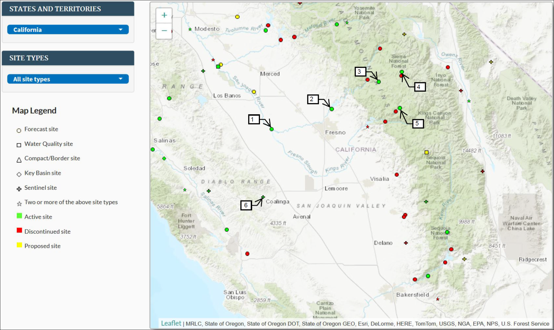
- San Joaquin River near Mendota
Network: Forecast
- San Joaquin River near Friant
Network: Forecast
- Big Creek near Huntington Lake
Network: Forecast
- South Fork of San Joaquin River near Florence Lake
Network: Forecast
- North Fork of Kings River near Cliff Camp
Network: Forecast
- Los Gatos Creek near Coalinga
Network: Sentinel
Elevation Certificates
The Fresno County Department of Public Works and Planning also, copies of available FEMA Elevation Certificates for structures and substantial improvements constructed in Special Flood Hazard Areas. Below is a link to the most current records of Elevation Certificates on file. Copies of finished construction Elevation Certificates can be provided upon request.
Elevation Certificate Log (XLS, 634KB)
Inspections
Onsite inspections are available for owners who wish to determine areas that can be improved to reduce flood damage please contact the Fresno County Department of Public Works and Planning Development Services Section at (559) 600-4022, Inspection fees may apply.
Flood Preparedness
How to Obtain Sandbags for Flood Prevention
Emergency Preparedness and Response
FEMA FloodSmart Resources
Important Flood Protection Information for Residents(PDF, 37KB)
Flood Preparation and Safety(PDF, 356KB)
Ready.gov Flood Information
Fresno County Flood Protection Information(PDF, 60KB)
Disaster Response Steps(PDF, 185KB)
So You Live Behind a Levee(PDF, 2MB)
Turn Around, Don't Drown(PDF, 6MB)
Construction within Special Flood Hazard Areas
The County's first Flood Insurance Rate Map Effective Date was December 1, 1982. If a structure was built prior to this date and is located in a Special Flood Hazard Area, the structure may not be elevated to current standards. This may result in an increased flood insurance premium.
Fresno County Flood Hazard Ordinance
Elevation Certificate(PDF, 5MB)
Floodproofing Certificate (Non-residential)
A Guide for Consumers(PDF, 2MB)
Building in a Special Flood Hazard Area(PDF, 35KB)
FEMA 259 - Engineering Principles and Practices for Retrofitting Flood-Prone Residential Structures(PDF, 56MB)
FEMA 312 - Homeowner's Guide to Retrofitting(PDF, 52MB)
Flood Insurance
Most homeowners insurance does not cover flooding losses. Only flood insurance covers damage from rising waters. Because Fresno County is a participant in the NFIP, residents receive a discount on their annual insurance premium. ACT NOW! It may take up to 30 days for flood insurance to be effective!
Why You Need Flood Insurance(PDF, 7MB)
Answers to Tough Questions about the NFIP(PDF, 325KB)
Understanding Your Flood Insurance Policy(PDF, 117KB)
NFIP Grandfathering Rules for Agents(PDF, 491KB)
Repetitive Loss(PDF, 9MB)
(PDF, 9MB)Top Ten Things to Know About Flood Insurance(PDF, 45KB)
Floodplains
Floodplains have an essential role in flood protection. Floodplains provide room for floodwaters, reducing pressure on dams and levees. It is critical that floodplains remain free of debris or hazardous waste to reduce the risk of injury in the event of a flood.
Report Illegal Dumping
Protecting Floodplain Resources(PDF, 45MB)
Sensitive Status Species(PDF, 29KB)
Floodplain Functions and Societal Values(PDF, 351KB)
San Joaquin River Parkway
Protecting Natural Functions Regulations
Contacts